

11:00 PM to 8:30 AM on 30 minute increments--August 18th and 19th
On August 18th and 19th, 2007, a surprising storm hammered central Oklahoma. Tropical Storm Erin made landfall at Corpus Christi, Texas on August 16th, bringing severe flooding to that area. It dissipated for the most part after landfall, and curved across west Texas. The remnants of the storm started moving into Western Oklahoma on August 18th. And an amazing thing happened. The totally disorganized storm reorganized itself, strengthening as if it was over open and hot ocean. The reasons for the storm "bombing" will probably be discussed for a long time; it has almost never happened that a tropical system strengthened over land.
But it happened this time. When I started tracking the storm at about 7:00 AM, the storm had already reorganized and was bearing down on central Oklahoma. The National Weather Service Norman, Oklahoma office was keeping updates posted on their website discussing the situation:
Regional weather discussion... potential will remain high for excessively heavy rain and dangerous flash flooding through mid morning over much of central and south central Oklahoma. The potential also will continue for damaging winds and isolated tornadoes. Conditions will improve by midday. An extraordinary weather event continues to unfold over central Oklahoma early this morning as the remnants of Tropical Storm Erin have intensified... resulting in what amounts to an inland tropical storm. At 650 am... the well-defined center was located very close to Piedmont based on radar and surface observations... moving slowly east at 10 mph. A band of flood-producing rain was located from Crescent to Wellston to Shawnee to Pauls Valley... and southwestward to near Duncan. Other heavy showers and thunderstorms were located over south central Oklahoma... from the Turner Falls area south and southwestward to west of Ardmore. The heavy rain areas were moving slowly east at around 10 mph. Strong winds will continue in the immediate vicinity of the storm center... especially within 50 miles of the center near Piedmont. Sustained winds of 25 to 35 mph will be likely... and gusts to 60 mph will be possible. Weak tornadoes will remain possible in these areas as well. The main hazard will be torrential rain and flash flooding. Rainfall of 2 to 3 inches per hour will quickly inundate low lying areas and lead to impassable roads and locally very dangerous flooding conditions. Although heavy rain will continue to rotate around the low center as it moves slowly east across central Oklahoma... rainfall will end gradually from west to east as the storm system moves into eastern Oklahoma. Much of the heavy rain will end in central Oklahoma by late morning. Flooding will likely continue through much of the morning due to widespread overnight rainfall ranging from 4 to 8 inches... and locally higher amounts."
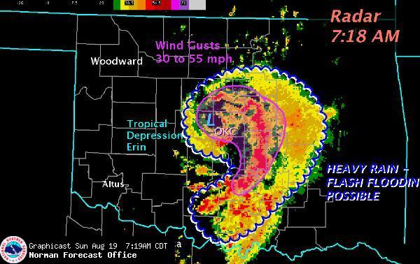
At about 7:30 AM on the 19th, the eye (which reappeared during the night) was approaching Oklahoma City. At this point, the worst damage was being done--the worst of the storm hit the counties just west of Oklahoma City.:
Weather Synopsis...A rare and extraordinary event is unfolding this morning as the rejuvinated remnants of Tropical Storm Erin move across central OK. Very heavy rainfall and potentially life-threatening flooding will be the main concern. Winds of 30 to 40 mph, and gusts above 50 mph, also will also be likely. Conditions will improve later today from west to east, as the storm moves into eastern OK. The good news is that the clouds and rain will take the edge off of the summer heat. Most of OK and north TX will stay in the 80s today.
Essentially, the low strength tropical depression regained strong tropical storm status over land. Consistent straight-line winds of 50 mph were measured, with gusts up to 85 mph; this puts the storm well into tropical storm levels. The rainfall west of the metro area reached "100 year" levels--essentially, this was a once in 100 years storm in terms of rainfall. Several areas reached 10 inches of rain.
At 8:00 AM, the storm was centered over Edmond (north of OKC) and was just reaching the end of its highest-intensity time.
SHORT TERM FORECAST
NATIONAL WEATHER SERVICE NORMAN OK
805 AM CDT SUN AUG 19 2007.NOW...
...REGIONAL WEATHER DISCUSSION...
POTENTIAL WILL REMAIN HIGH FOR HEAVY RAIN AND DANGEROUS FLASH FLOODING INTO LATE MORNING OVER MUCH OF CENTRAL AND SOUTH CENTRAL OKLAHOMA. WINDS TO 40 MPH ALSO WILL CONTINUE. CONDITIONS WILL IMPROVE BY MIDDAY.
AN EXTRAORDINARY WEATHER EVENT CONTINUES OVER CENTRAL OKLAHOMA THIS MORNING AS THE REMNANTS OF TROPICAL STORM ERIN HAVE INTENSIFIED... RESULTING IN WHAT AMOUNTS TO AN INLAND TROPICAL STORM. AT 8 AM... THE WELL-DEFINED CENTER WAS LOCATED OVER THE SOUTH PART OF EDMOND BASED ON RADAR AND SURFACE OBSERVATIONS... MOVING SLOWLY EAST AT 10 MPH. BANDS OF FLOOD-PRODUCING RAIN WERE ROTATING AROUND THE CENTER ACROSS MUCH OF CENTRAL AND SOUTH CENTRAL OKLAHOMA. GENERAL MOVEMENT OF THE HEAVY RAIN AREAS WAS EAST AT AROUND 10 MPH.
STRONG WINDS WILL CONTINUE IN THE IMMEDIATE VICINITY OF THE STORM CENTER... ESPECIALLY WITHIN 50 MILES OF THE CENTER NEAR EDMOND. SUSTAINED WINDS OF 20 TO 30 MPH WILL BE LIKELY... AND GUSTS TO 50 MPH WILL BE POSSIBLE. THE MAIN HAZARD WILL BE TORRENTIAL RAIN AND FLASH FLOODING. RAINFALL OF 1 TO 3 INCHES PER HOUR WILL QUICKLY INUNDATE LOW LYING AREAS AND LEAD TO IMPASSABLE ROADS AND LOCALLY VERY DANGEROUS FLOODING CONDITIONS.
ALTHOUGH HEAVY RAIN WILL CONTINUE TO ROTATE AROUND THE LOW CENTER AS IT MOVES SLOWLY EAST ACROSS CENTRAL OKLAHOMA... RAINFALL WILL END GRADUALLY FROM WEST TO EAST AS THE STORM SYSTEM MOVES INTO EASTERN OKLAHOMA. MUCH OF THE HEAVY RAIN WILL END IN CENTRAL OKLAHOMA BY LATE MORNING. FLOODING WILL LIKELY CONTINUE THROUGH MUCH OF THE MORNING DUE TO WIDESPREAD OVERNIGHT RAINFALL RANGING FROM 4 TO 8 INCHES... AND LOCALLY HIGHER AMOUNTS.
What did the storm do? It produced several tornados in western Oklahoma as it intensified on Saturday the 18th. It produced severe straight-line winds in a few areas west of Oklahoma City. It dropped some of the heaviest rainfall ever seen in the state--essentially, 7 inches in 7 hours in Norman. Such a rate was unprecedented. And this, of course, produced the worst impact: flash flooding of epic proportions. Kingfisher was 25% under water. El Reno's low areas flooded. Any place that can flood in Norman flooded. Since the storm was of such short duration, the worst flooding occured in places where it takes less than 12 hours for the whole watershed to contribute. This is termed the "time of concentration" in hydrological analysis. Thus, the major rivers, while flooding, were not as unusually high as the smaller streams, which rose higher than (in many cases) recorded history. An exception was the North Canadian River, which flows east through Oklahoma City. Watonga was right in the area of heaviest rain, and the North Canadian River set an all-time record for flood levels. The river also crested high in El Reno and Yukon, higher than anything since the 1930s.
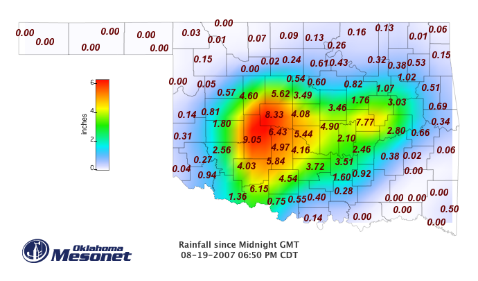
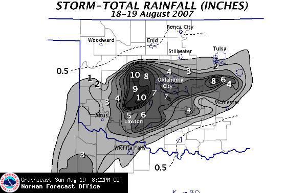
The mesonet graphic above presents official rainfall totals for the 19th alone (up to 6:50 PM). The national weather service image shows essentially the final totals. Many areas set all-time records for most rain in one day. Finally, the last graphic is also from the National Weather Service and gives the overall storm track and rainfall accumulations.
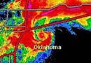
Here is a radar loop of the storm at the eye entered the metro area. Note the remarkable tropical storm radar signature.
Close-up of central Oklahoma: 7:06 AM to 7:31 AM on 5 minute increments
Finally, a 40-frame composite from 6:47 AM to 10:05 AM on ~5 minute increments is available HERE. It is 1.56mb--that is why I didn't put it in this page directly.
An excellent blog entry by someone in Oklahoma with considerably more meteorological skill than I can be found at Weather or Not.
A few photos of the flooding on Little River in northern Cleveland County on the afternoon of the 19th:
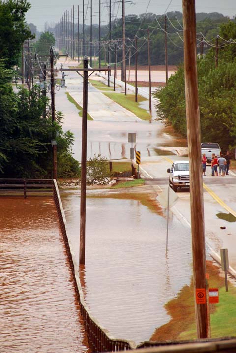
Little River valley and Franklin Road at about 3PM, soon after Little River crested. The river is normally about 8 feet wide and less than a foot deep up here near the headwaters, and confined to the bottom of the gully. Toby Keith's land is to the left of the road.
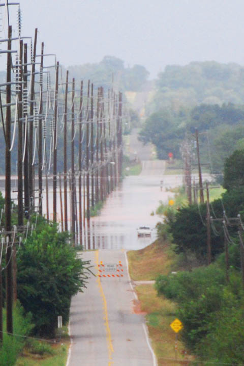
Franklin Road east of our house. This photo was taken with a zoom and cropped, so the perspective is collapsed--the area flooded is actually about 1 mile long.
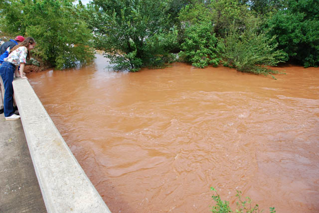
Little River a few blocks from our home. The water is flowing in what normally is a gorge some 40 feet wide and as many deep. Now, the water is within 3 feet of the girders on the bridge, and is overflowing to fill much of the valley.
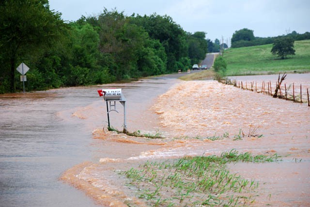
Looking the other way from the bridge, the Little River races across the road and into the Little River Ranch. Most of the bottom land in Little River Valley was flooded.
Additional Links
National Hurricane Center final report on Tropical Storm Erin
Norman Forecast Office Fall 2007 Newsletter (Feature on Erin)